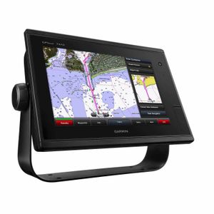
Garmin GPSMAP 7410 Multifunction Display with Worldwide Basemap Charts
The Garmin GPSMAP 7410 is a multifunction chartplotter that impresses in high performance, featuring a high-resolution 10″ multi-touch widescreen display. It has a built-in 10 Hz GPS that updates position and heading 10 times per second, offering support for external NMEA® 2000 GPS 19x. Network capabilities extend to Garmin Network and NMEA 2000 support for functionalities such as radar, autopilot, multiple screens, instruments, FUSION-Link, sensors, black box sonar, digital switching, thermal cameras, GRID, and more. The device comes with premium sailing features, including laylines, enhanced wind rose, tide, and current slider. Plus, it includes racing features such as a virtual starting line, time to burn, and a synchronized race timer, coupled with a built-in Wi-Fi® for using Garmin Helm™ and BlueChart® Mobile.
Product Specifications
- 10-inch multi-touch widescreen display (1280 x 800 WXGA) with worldwide basemap.
- High-sensitivity internal 10 Hz GPS/GLONASS.
- Full network capability for Garmin Marine Network and NMEA 2000®, and NMEA 0183 support.
- Support for GSD™ premium sonar and GCV™ scanning sonar modules.
- Advanced sailing and sail racing features.
Product Box Contents
- GPSMAP 7410 J1939 with worldwide basemap.
- J1939 connector offering a dedicated CAN port for receiving engine data.
- Power/data cable.
- NMEA 2000® drop cable.
- T-connector.
- Bail mount with knobs.
- Flush mount kit.
- Protective cover.
- Documentation.
The Garmin GPSMAP 7410 supports both Garmin Marine Network and NMEA 2000, suitable for cruisers, sailors, and sailing racers who prioritize high performance, feature integration, and ease of operation. Full-network compatibility also lets you extend your boat’s capabilities, offering support for radar, autopilot, instruments, multiple screens, FUSION-Link, sensors, and more.
Simultaneous Multiple Device Support
Users can share features with other compatible GPSMAP units, such as radar, GCV 10 DownVü, and SideVü scanning sonar, supplemental maps, and user data, among others. This allows any data entered into one chartplotter to automatically sync with others in the network. Furthermore, users can review hazard points along the calculated path and save plotted Auto Guidance paths for future navigation.
Sonar Views
Advanced sonar modules such as Panoptix Down and Panoptix Forward transducers are supported, allowing marine users to visualize multiple views of the underwater environment in real-time.
Additional Information
This chartplotter is tailor-made for creating personalized HD fishing maps with 1-foot contours, track turning points, view target depths, commission autopilot, and collaborate with Axis cameras for surveillance and situational awareness. It also supports GPX software formatting for easy waypoint transfers, making Garmin’s GPSMAP 7410 more than just a standard navigation tool.
Please note, an SD™ card with your BlueChart® g2 Vision® or LakeVü™ HD Ultra cartography is required for some functionality.